[ad_1]
What could evolve into the nation’s biggest snowstorm of the year was forecast for a wide swath of the northern U.S. Monday through Wednesday, while parts of the Midwest and South were bracing for another round of damaging tornadoes, especially on Tuesday.
Almost 50 million Americans are already at risk for severe storms and potential tornadoes Tuesday, according to the National Weather Service’s Storm Prediction Center. Cities such as Chicago, Kansas City, Tulsa, St. Louis and Des Moines are all in the risk area. The storms “could pose a risk for a few strong tornadoes, large hail and damaging wind gusts,” the SPC said.
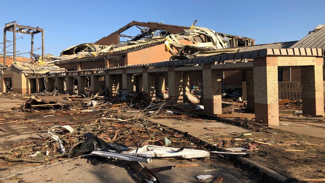
Many cities and towns are recovering from a surge of severe storms that resulted in dozens of confirmed or suspected tornadoes in at least eight states and 32 deaths.
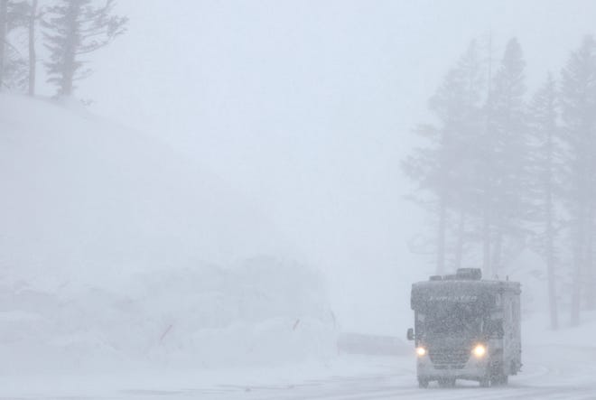
Meanwhile, Colorado, Minnesota, Nebraska, North Dakota, South Dakota, Utah and Wyoming are among states that will face the brunt of a winter storm that could break April snow records, the National Weather Service warned. Up to 30 inches of snow was possible in portions of South Dakota, the weather service in Rapid City said.
“Strong winds and heavy snow will create whiteout conditions and significant drifting snow,” the weather service said, adding that the result could be “dangerous to impossible driving conditions and considerable disruptions to daily life.”
Developing:
►The weather service confirmed that EF-3 tornadoes with winds of up to 165 mph touched down in Wynne, Arkansas, and in Covington and Adamsville, Tennessee, on Friday and Saturday.
►The weather service office in Chicago said at least 16 tornadoes have been confirmed in the area so far, and damage surveys were ongoing.
BRUTAL STORMS:Death toll at 32 after tornadoes hit South, Midwest, East; more possible this week
Monday’s severe weather threat is in the South
There is a small area of the South where severe storms are possible on Monday, the Storm Prediction Center said. A tornado watch has been issued for portions of Alabama, Georgia and the Florida Panhandle until 5 p.m. EDT. “Thunderstorms moving into the region will pose a threat for damaging winds, large hail, and a few tornadoes,” the SPC said.
More than 1.3 million people live where tornadoes are possible Monday, the weather service said.
IS A TORNADO WATCH OR WARNING WORSE? What to know about preparing for these violent storms
16 states face possible tornadoes days after scores strafed nation
At least 16 states, most in the Midwest and South, are at risk for severe weather and tornadoes on Tuesday, AccuWeather reported.
“The combination of warm, moist air and strong winds from the ground on up through the jet stream level of the atmosphere will allow for numerous severe thunderstorms as well as tornadoes,” AccuWeather meteorologist Andrew Johnson-Levine said.
The Storm Prediction Center has placed portions of Iowa, Illinois and Missouri in a “moderate” risk zone for severe weather Tuesday. This is Level 4 of its 5-level severe risk scale.
Nearly 100 preliminary tornado reports were being investigated by the SPC after the wild storms that swept across much of the Midwest and East on Friday and Saturday. As of Monday morning, the weather service has confirmed 66 tornadoes.
Battered Arkansas braces for more storms
Arkansas awaited more storms even as it remained in recovery mode from storms and tornadoes late last week that claimed five lives. Four of the deaths were in the city of Wynne, where homes and businesses were battered across the community of 8,000 people, 50 miles west of Memphis.
In Little Rock, Mayor Frank Scott said 50 people were injured and almost 3,000 homes, businesses and other structures were damaged, most by one tornado that tore a 6.5- mile path through west Little Rock.
The weather service in Little Rock said severe weather was possible once again across the state from Tuesday evening through Wednesday morning.
“Damaging winds, tornadoes and large hail are all possible,” the weather service warned. “Be sure to have a plan in place before severe weather occurs. Know your safe place!”

Rockies to get heavy snow
The Pacific Northwest began to see snowfall over the weekend, and a winter storm will move across the central and northern Rockies and drop heavy snow all day Monday.
“A few feet of snow is possible across the higher terrain of Utah, Colorado and Wyoming, with lower elevations also seeing heavy snowfall amounts up to a foot,” the weather service said.
The affected areas could have “difficult to impossible” driving conditions Monday.
‘Biggest snowstorm of the year’ sparks blizzard warnings in Dakotas
The storm is likely to create blizzard conditions Monday night, “setting the stage for what could be the biggest snowstorm of the year across parts of the northern Plains.” AccuWeather said wind gusts could reach up to 60 mph. The weather service said wind chills below zero “could be life-threatening to anyone stranded outdoors.”
“This next storm will be a classic spring blizzard,” AccuWeather senior meteorologist Joe Lundberg said.
Blizzard warnings were issued across much of the Dakotas and into northern Nebraska and eastern Wyoming. The warnings were set to begin late Monday and last through at least Tuesday night in many areas.
TORNADO SEASON:Here’s how to prepare your home
Winter storm tracker
National weather radar
Follow Jordan Mendoza on Twitter: @jordan_mendoza5.
[ad_2]
Source link


