


[ad_1]
A tornado outbreak caused widespread alarm and potential havoc Friday evening as federal forecasters warned of rare twister emergencies that spawned damage and injuries in Arkansas.
A “tornado emergency” was issued mid-afternoon Friday for the Little Rock area as a confirmed “large and destructive tornado” was seen on the ground, the National Weather Service said. A tornado emergency is issued when a severe threat to human life or catastrophic damage is imminent or ongoing.
Injuries were reported, but an exact count was not yet available.
Videos and photos posted online showed damage to buildings in the Little Rock area. The Little Rock Fire Department reported heavy damage and debris in the western end of the city.
Is a tornado watch or warning worse?:What to know about preparing for these violent storms
READ MORE:Bad tornado season in US is set to get worse
Arkansas Governor Sarah Huckabee Sanders tweeted “Significant damage has occurred in Central Arkansas….Praying for all those who were and remain in the path of this storm. Arkansans must continue to stay weather aware as storms are continuing to move through.”
The weather service issued a separate tornado emergency late Friday afternoon for the towns of Parkin and Earle in eastern Arkansas. “Take cover now,” the weather service said, also warning of a catastrophic damage threat. That tornado was confirmed to have hit Wynne, Arkansas, according to the weather service in Memphis.
Nearly 70,000 customers in Arkansas were out of power on Friday afternoon, according to poweroutage.us, which tracks outages. Outages were also reported in Oklahoma, Kansas, Missouri and Texas.
Several other tornado warnings were also issued across Arkansas, where residents were told to take cover in basements and interior rooms away from windows. One was also issued in central Illinois near Peoria.
Tornado warning are issued when a tornado has been spotted or one is indicated on radar.
Tornadoes were also reported in Iowa Friday afternoon, the Storm Prediction Center said.
Many of the reported tornadoes were moving at highway speeds of 55 to 60 mph.
About 89 million people in at least 15 states – from Texas to Alabama in the South all the way up north to Wisconsin and Michigan – are at risk from the “explosive” storms.
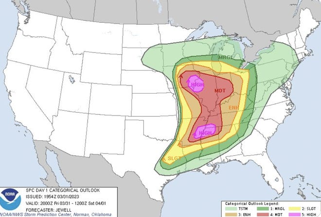
On Friday, two rare “high risk” zones for severe weather were issued by the Storm Prediction Center, one centered near Memphis and the other on the border between Iowa and Illinois. It’s the first time in more than two years the SPC has issued a high risk.

A tornado watch – which means weather conditions are ripe for tornadoes to form – was also issued for a large portion of the central U.S., all the way from Iowa to Arkansas.
The SPC said “a dangerous severe weather outbreak is likely across a large portion of the central states this afternoon into tonight. Long-track, strong to potentially violent tornadoes are forecast across a broad region of the Mississippi Valley.”


Bob Larson, senior meteorologist at AccuWeather, said “this storm has far-reaching effects and a number of different weather elements that will wreak havoc, and that’s going to be the big story.”
Meanwhile, heavy snow and strong winds were expected to produce blizzard conditions from the Dakotas to northern Michigan.

Here’s what you need to know about Friday’s weather:
What is a tornado emergency?
A step above a tornado warning, issued by the National Weather Service in “exceedingly rare” situations, when:
A severe threat to human life or catastrophic damage is imminent or ongoing.
Visual or radar evidence such as a reliable source confirms a tornado or a radar picks up the signature of a ball of debris inside the tornado.
Friday’s severe weather forecast: Mississippi braces for more
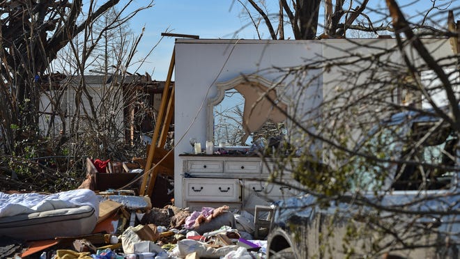
The storm that will slam into the Midwest and South will impact Mississippi, where tornadoes left 22 dead and dozens injured after tornadoes tore through several towns last week.
Larson said to expect a “more potent” storm this time around. “That doesn’t mean that it’ll be worse in terms of tornado outbreaks, but I do think there’ll be a larger area affected than what we had last week,” Larson said.
“Both north and south, really any direction, over several hundred miles removed from the storm center is going to be a large area of high winds that can cause problems,” he added.
Locations including Wichita and Kansas City, Kansas; Oklahoma City; St. Louis; and Chicago are likely to experience 50- to 60-mph wind gusts throughout Friday, according to Larson.
By Friday night, the storm will move eastward into Tennessee, including Memphis and Nashville. On Saturday, it’ll move east from Ohio through all of Pennsylvania, New Jersey, Delaware, Maryland and part of New York state.
Some of those areas will be slammed with 60- to 70-mph wind gusts, Larson said.
Map shows where severe storms are most likely Friday
Biden visited tornado-ravaged Mississippi town
President Joe Biden on Friday visited areas severely damaged by tornadoes last week. Rolling Fork and nearby Silver City, Mississippi, lost around 300 homes and businesses, with hundreds of other buildings badly damaged.
The president and first lady Jill Biden surveyed tornado damage, met with affected homeowners and first responders and received an operational briefing from federal and state officials.
They were joined by Gov. Tate Reeves, Mississippi Sen. Cindy Hyde-Smith and Rep. Bennie Thompson.
Biden announced that the federal government will cover the total cost of the state’s emergency measures for the next 30 days, including overtime for first responders and debris cleanup.
Is a tornado watch or warning worse?:What to know about preparing for these violent storms
Tornado preparedness tips
The National Weather Service says it’s always important to have an emergency plan in place in the event of severe weather, including designating a “safe place” in your home, preferably away from windows and in an interior room. Keeping supplies handy like flashlights, batteries, food, water, clothes and shoes is also recommended.
The weather service also recommends having multiple ways to get updates, including push alerts, local TV reports, weather apps and a NOAA weather radio.
“I think the No. 1 message that people need to have is that they need to be prepared,” said Pam Knox, director of the University of Georgia Weather Network. “Don’t rely on outdoor sirens as a warning. Instead, have a weather radio or smartphone at the ready.
“And know where you’re going to go if you hear a tornado warning,” she said.
It’s been a bad start to the USA’s tornado season
The U.S. has already seen more than 300 tornadoes and 31 deaths in 2023.
With 311 tornadoes so far, according to Storm Prediction Center data, it’s the third-most-active start to a year on record in the U.S.
“We should be at about 200 tornadoes for today’s date,” Victor Gensini, associate professor at Northern Illinois University, told USA TODAY on Thursday. “So we’re running about 100 tornadoes above average, and we have been the entire year.”
READ MORE:Bad tornado season in US is set to get worse
US weather watches and warnings
Blizzard warning issued in Plains, upper Great Lakes
The same storm system is expected to produce a band of heavy snow, with blizzard conditions possible from the central Plains to the upper Great Lakes region from Friday to Saturday, Larson said.
The National Weather Service issued a blizzard warning from Friday afternoon through Saturday morning for a large swath of South Dakota and neighboring states. An ice storm warning will be in effect in the area through Friday afternoon.
Some spots in South Dakota could pick up as much as 20 inches of snow from the storm, the weather service said.
About 2 to 4 inches of snow are expected in most other places, with winds gusting as high as 55 mph.
“Power outages and tree damage are likely due to the ice,” the weather service said. “Travel could be nearly impossible. Patchy blowing snow could significantly reduce visibility. The hazardous conditions could impact the morning or evening commute.”
The weather service urged drivers who must travel to bring flashlights, food and water in case they get stuck.
More winter weather in Northwest
Meanwhile in parts of Oregon and Washington, a winter storm warning goes into effect at 5 p.m. Friday and will last through late Sunday.
Snow accumulations could reach up to 48 inches at higher elevations in the Cascades, and winds are expected to reach 40 mph.
Winter storm map
National weather radar
More coverage from USA TODAY

Contributing: The Associated Press; Dinah Voyles Pulver, USA TODAY
[ad_2]
Source link